|
|---|
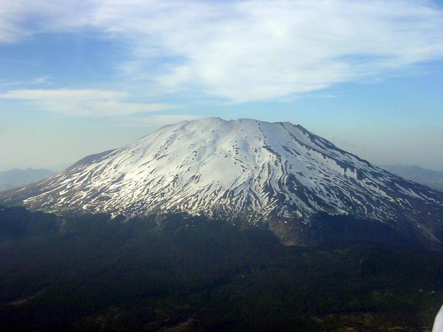
Mount Saint Helens, the most infamous volcano in the continental U.S.
24 years after May 18, 1980 when the mountain blew its top killing
60 people, one can still see the
forest scars and the frozen mud and ash slides. In places the ash is
hundreds of feet thick and the course of the Touttle river was
forever changed.
|
|
|---|
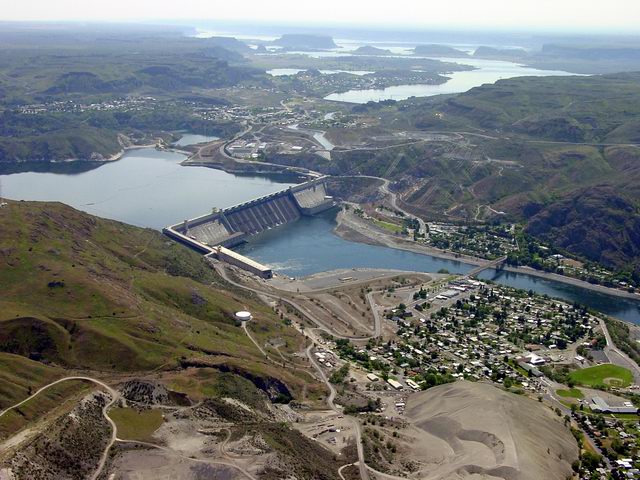
Grand Coulee Dam. ( The Spillway Faces Due North. )�To the left, above
the dam, is Lake Roosevelt and in the background is Banks Lake. The Town
of Coulee Dam is below the dam and the City of Grand Coulee is
between�Lake Roosevelt and Banks Lake.�Electric City is along the Left
side of the North End of Banks Lake. The Grand Coulee Airport is in the
right background on the rightmost tip of land seen jutting out into the
lake from the left shore, about 2 miles South of Electric City.
|
|
|---|
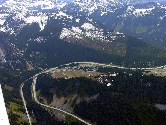
Snoqualmie Pass and the Ski Acres Area. The road is I-90 and the
photo was taken from 7500 feet. To the right is a clearing that is
the Hyak Ski Area. This is the main east-west route through the
Cascade Mountains linking Seattle, WA with the rest of the continent.
Very safe mountain crossing given enough altitude. A flat valley
starts just beyond the summit and 3 parallel lakes are always
within glide distance.
|
|
|---|
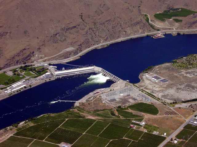
Rocky Reach Dam on the Columbia
River in the state of WA north of Wenatchee and south of Lake Chelan. The dam is
about 5 miles north of where the Wenatchee River joins the Columbia. Built in 1961
and expanded in 1971 it's peak capacity for all 11 generators is 1287 megawatts. Note
the orchards in the foreground.
|
|
|---|
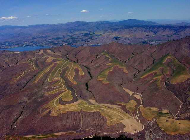
Chelan Butte: Behind this is Lake Chelan, WA. It looks like a housing development gone
bad. Or maybe it's a future golf course.
|
|
|---|
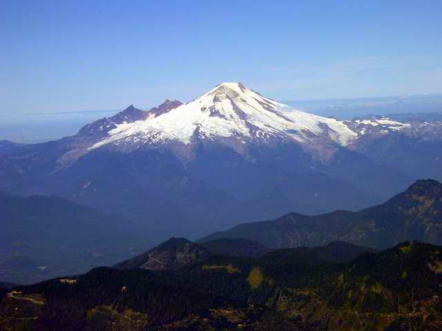
Mount Baker, WA from the southeast. Yet another DORMANT volcano in WA. Baker
Lake is obscured by the foreground ridge. 08/2003
|
|
|---|
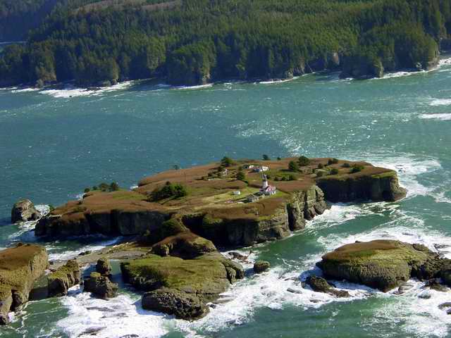
Tatoosh Island, WA
on the Olympic penninsula. This is it. There ain't no more. The westernmost tip of the
contiguous 48 states. Taken 10/2003. CYRUS WALKER - The tug Cyrus Walker appeared in a new role
in the summer of 1867. In charge of Captain Gove and Engineer Williamson she was dispatched to
Neah Bay to quell a disturbance among the Indians. A Clallam Indian had been killed by one of the
Neah Bay tribe, and, when the agent arrested the murderer, his tribesmen forcibly released him. A
messenger was sent to Steilacoom, and a lieutenant, surgeon and thirty-two privates were sent to ...
See link for a lot more ...
|
|
|---|
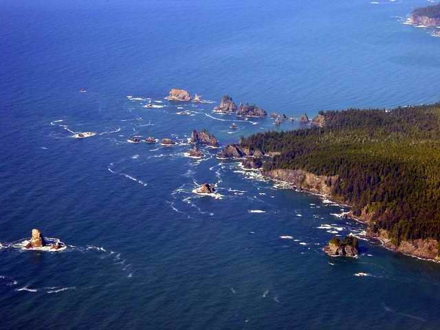
Flattery Rocks, WA south of Cape Flattery which is the western most point in the
continental USA. 08/2003.
|
|
|---|
Cape Flattery, WA. The Flattery Rocks are in the lower right, the cape is in
center background. The far background is Vancouver Island, British Columbia,
Canada. The point of the cape is the westernmost point of the continental
USA. 08/2003
|
|
|---|
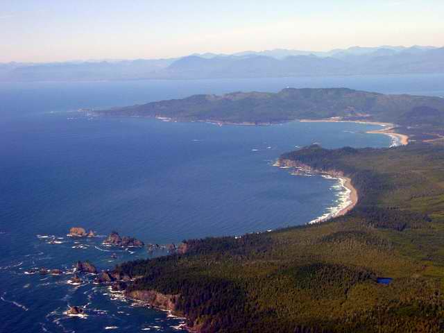
La Push, WA on the Olympic penninsula. The water is the Pacific ocean. There is a
town and large marina under the fog somewhere. The Quillayute Indian Resevation is in
the foreground. The Quillayute River meets the Pacific under the fog. This is
looking north. Taken 08/2003
|
|
|---|
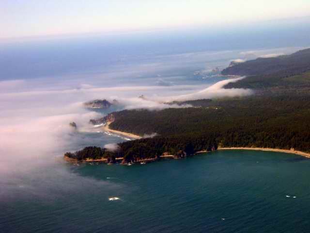
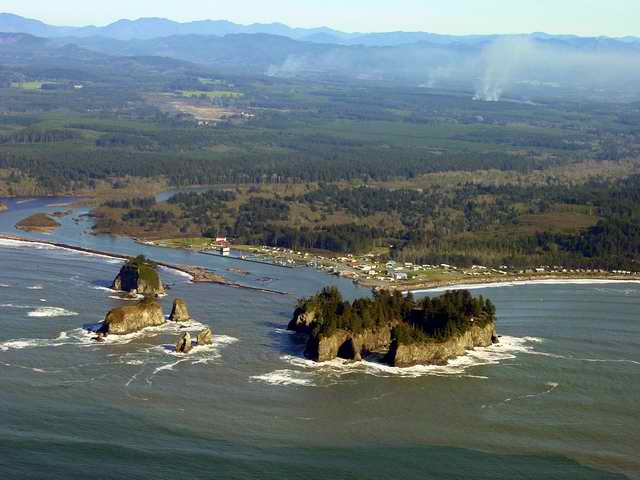
Here is what was under the fog looking east. Some field burning is going on
around Forks, WA. The Quillayute airport (UIL) can be seen mid-left. 10/2003
The center treed island is James Island.
James Island is the largest of the group of sea stacks,
called Los Frayles by Bruno Heceta in 1775. It wasn't an island until the Corps of Engineers
rerouted the Quillayute River, isolating the sea stack from the village. Called Aka-lat (on top
of the hill) by the Quileute Tribe, this precipitous horse shoe shaped rock, accessible only
on the northeast (ocean) side by way of a steep, difficult path ascending to the 150-200 foot
fir topped summit, was a secure fortress protecting the Quileutes from raids by the Makahs,
who paddled down from Neah Bay seeking women and slaves. See the link for more ...
|
|
|---|
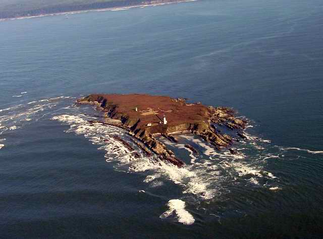
The aptly named Destruction
Island. 3 NM off the coast it is one gnarly looking piece of rock. 10/2003. This
rugged, half-mile long, 300-foot wide island was used as an anchorage by two Spanish ships on July
14, 1775. While anchored under the lee of this island, the Spanish explorer, Bodega y Quadra sent
a small boat's crew of seven men ashore on the mainland three miles away for wood and water. The
party was massacred by Indians and their boat stolen. He named it the Island of Sorrows and sailed
away. In 1787, Captain Barkley (Barclay), in the Austrian East India Company's ship, Imperial Eagle,
also sent a party ashore from the island to the same fate. He named the river where the massacre
took place the Destruction River. The name was transferred to the lonely island when the river
was called by its Indian name, the Hoh. See the link for more ...
|
|
|---|
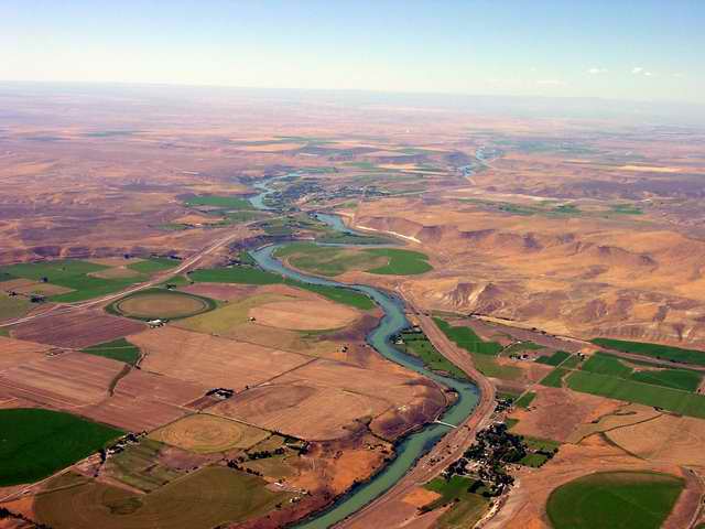
Glenns Ferry, ID, 50 miles southeast of Boise on the Snake River. Three Island
Crossing in Glenn's Ferry,
Idaho, pioneers were able to cross the dangerous Snake River.
It was extremely dangerous because of the swiftness and depth of the water. It has many
whirlpools that have a strong enough under toe to pull a man and his horse down under
the water and drown them. The pioneers used two of the three islands like stepping-stones
to cross the river. At this point of crossing it was most difficult because the wagons had
to be floated across the Snake River. Men would have to swim to the opposite bank of the
river, and then using ropes they would pull wagons across. See the link for more ...
|
|
|---|
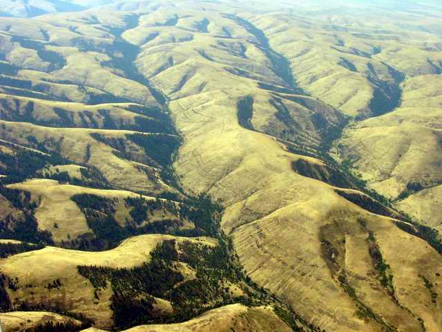
Wallowa-Whitman National Forest between Baker and Pendleton OR.
|
|
|---|
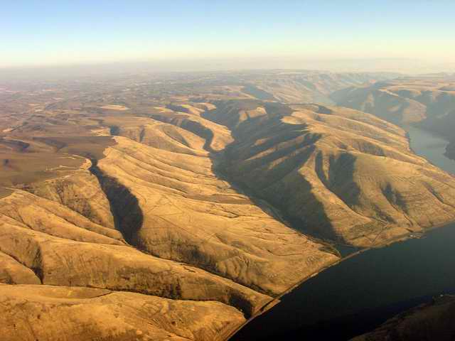
Wawawai Canyon on the Snake River canyon, 15 miles southwest of Pullman, WA.
The name, Wawawai is a Walla Walla Indian word meaning council ground. 'Wa' was
the Nez Perce word for talk, and tongue planted firmly in cheek, they called the
place of their annual pow wow with the Palus Pu, 'Talk, Talk, Talk!' The
entire community is under the waters behind Lower Granite Dam. (Davis).
A post office was established in 1885 and continued to 1967. The site was
inundated by the waters of Lower Granite dam.
|
|
|---|
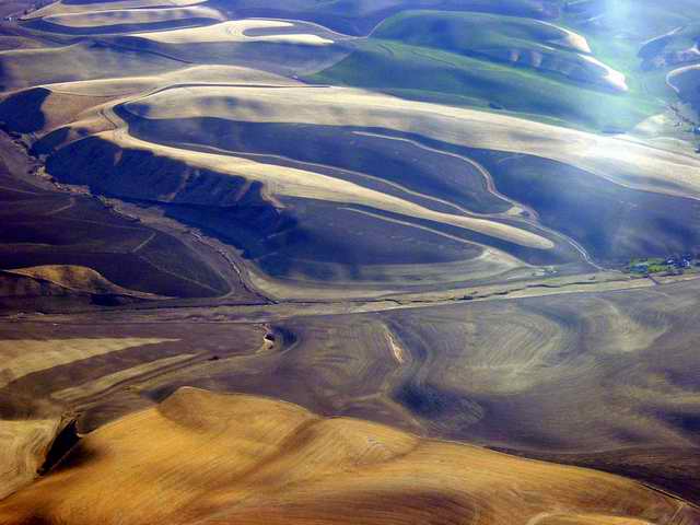
Some farmland on the Snake River close to Pullman. There is a bit of glare from
the window in the upper right.
|