Home Prev Next <info@primetab.com>
|
|
|
|
| Kahkuloa Head West Maui | Northshore West Maui | Molokai Sea Cliffs | Molokai Sea Cliffs |
|
|
|
|
| Molokai Sea Cliffs | Lahaina, West Maui | West Maui Mountains | West Maui Mountains |
|
|
|
|
| Olowalu, Maui | South shore Haleakala | Lava Flow | Cinder cone |
|
|
|
|
| Pimoe lava flow | Ahihi-Kina'u Preserve | Pu'u Mahoe | Makena Big Beach |
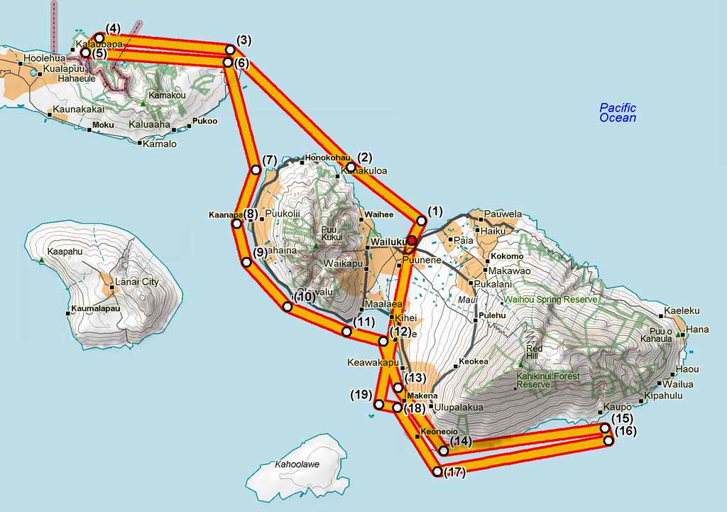
On a recommendation from Babe Candy of Babes and Airplanes I contacted Maui Aviators on the east ramp of the Kahului International airport. Maui Aviators has five aircraft among them a Cessna 152 Aerobat and a Piper Archer. Since the Archer is the same airframe with 20 more horsepower than the Warrior I own, I was checked out and then rented the Archer for a solo. Once the bit of paperwork was complete Jon sat down with me and spent 20 minutes going over the airport diagram, frequencies, and local procedures. Some things differ from the mainland such as traffic pattern altitudes are 800 AGL, west bound altitudes are 1000', 2000', or 3000', and east bound altitudes are 1500' and 2500'. Flights above 3000' seem rare in the islands. Then Ian checked me out with 3 landings in the Archer, two on runway 05 and one on runway 02. At the time ATIS reported the trade winds were 040 at 14 gusting to 21 knots - fairly usual and well-aligned with the runways. Roll outs were short. After the check out ride, Ian signed me off, and I took off from the main northbound runway, 02. 02 is 7000 feet long and 150 feet wide and shared with airliners. I had to wait for a B737 to take off, and when cleared for takeoff was warned to watch for wake turbulence, something I never hear. Since wake turbulence sinks, one avoids take off wake turbulence by lifting off before the lift off point of the other plane. One avoids landing wake turbulence by staying above the glide slope of the other plane and landing beyond the touch down point of the other plane. During most of the flight, from about waypoint 10 until landing the turbulence was moderate to severe. The atmosphere was unseasonably unstable and the air on the leeward side of the island was churned up pretty well. An airliner on approach for landing reported that at McGregor Point at 2700' they were experiencing moderate turbulence. This explained why I had experienced what I thought was severe turbulence 30 minutes earlier at the same location. I spent more time and effort simply flying the plane than I am accustomed. The landing on runway 02 was from a straight-in approach, with an airliner taking off when I was at 3 mile final. Winds were 040 at 21 gusting to 28 knots. No crosswind certificate for me. I touched down just beyond the numbers with a VERY short roll out.
|
|
|---|
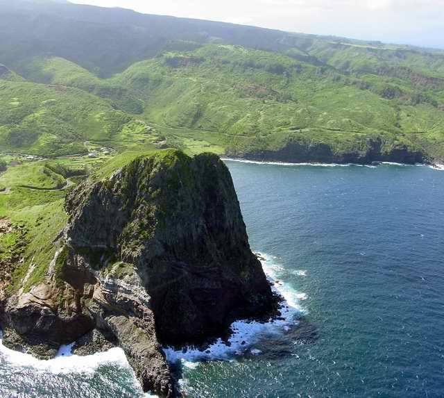
| After lift off I turned to the NW and maintained 1000'. On the windward side
of the islands the trades were still laminar and hence no turbulence. This photo
was taken at (2) on the chart. The rock is Kahakuloa Head. The small
settlement on the bay bears the same name.
|
|
|
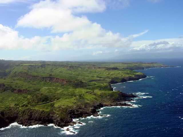
| This was taken from nearly the same place as the previous photo looking NW. The
far point in the right background is Nakalele Point the northmost tip of Maui.
The distance from Nakalele Point to the forground is about 3 miles. From
Nakalele Point moving toward the foreground are two large bays, Poelua Bay and
Hononana Bay. South of Hononana Bay is Mokolea Point. On the south side of
Mokolea Point is a round knob - center foreground. Just below the knob is a
very famous blowhole.
Beyond Nakalele point in the far background is the south shore of Molokai. The passage between Maui and Molokai is called Pailolo Channel and is about 8 nautical miles (about 9 statute miles) at its narrowest. The next 3 photos are of Molokai. |
|
|
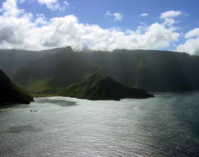
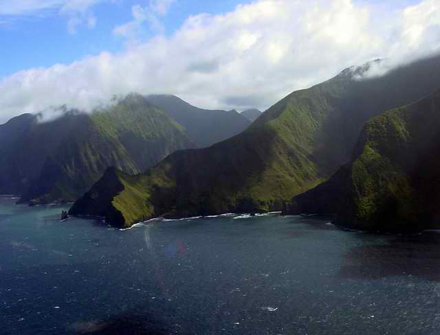
| This photo and the following 2 are of the famous Molokai northshore sea cliffs,
reputedly the highest sea cliffs in the world. At their highest they are about
1000'. There were long waterfalls cascading hundreds of feet to the sea.
Unfortunately, they did not photograph well under the clouds. This and the
next photo were taken on the first half of the leg from waypoints (3)
to (4).
|
|
|
|
|
|
|
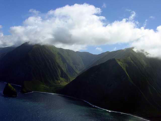
| The sea cliffs of Molokai. This photo is the same ridge as in the first photo
of the Molokai sea cliffs but from the other side between waypoints (4)
and (5).
|
|
|
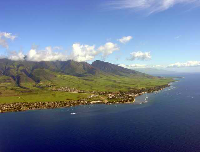
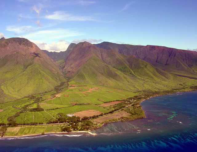
| Molokai is now behind and we are returning to West Maui. This photo was taken
from about mid-channel, waypoint (9), and we can see the distinctive 'T'
shape of Lahaina, an
historic whaling town. Now full of shops, art galleries, and restaurants, a
stroll down it's main street is an enjoyable afternoon. Don't miss the huge
banyan tree near the south end of town. If you get there an hour before sunset,
you will experience the cacaphony of thousands of Myna birds returning to roost
for the night.
Until this point the air was fairly smooth. The first hints of turbulence
started about here and soon increased. Note the deep cleft in the West Maui
mountains beyond Lahaina.
|
|
|
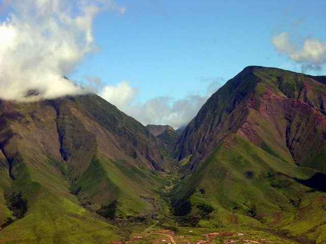
| Here is that cleft. The settlement and district is Launiupoke. This cleft
and the next to the south join with the Io valley that cuts into the mountain
from the other side out of Wailuku.
|
|
|
| This is a close up of the Launiupoke valley.
|
|
|
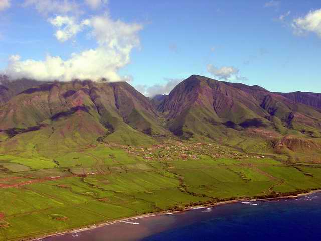
| Here is the next cleft to the south, waypoint (10). The point and
copse of trees just left
of center foreground is Olowalu. The trees hide a restaurant, Chez Paul, and
a Presbytarian Church Camp, Camp Pecusa, which extends to the water. Note the
coral reef surrounding the point. Camp
Pecusa is the first place I ever stayed in the islands. A friend rented the
camp for a 35 year old birthday party. It was rustic accommadations, and some
interesting stories. The caretakers are wonderful folk.
From this point the turbulence became intense. There are no photos between this point and waypoint (14) because it was taking all my attention to fly the plane. Previously mentioned McGregor Point is 6 miles south at waypoint (11). |
|
|
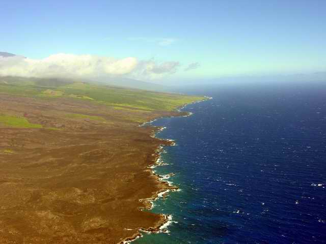
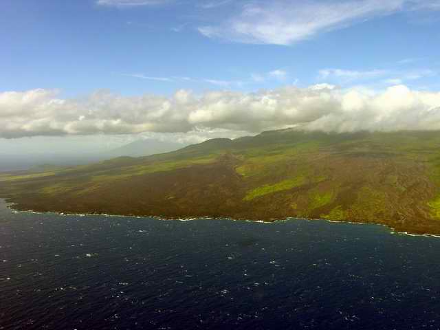
| At this position the turbulence had abated enough for me to again snap a few
photos. We have rounded the south tip of the volcano Haleakala and are looking
at its south shore, the Kanaio Coast. We are looking out across the Pimoe 1766
lava flow, less than 250 years ago. The green point in the background is
Wekaa Point, the bleb of lava just before the point is Kanaloa. Note the cinder
cone upcountry from the point and under the clouds. This is called the
Luala'ilua Hills.
|
|
|
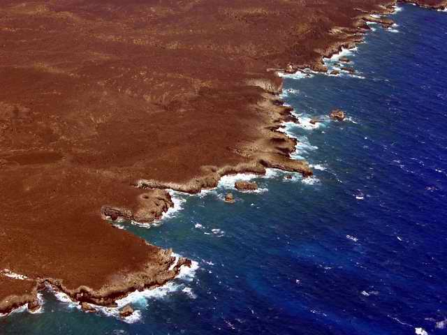
| This is a closeup of the Pimoe 1766 lava flow on the Kanaio Coast. I love the
contrast in this photo.
|
|
|
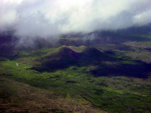
| Here is a closeup of the Luala'ilua Hills. The narrow road that skirts the lower
edge of the hills can barely be discerned. This is part of the infamous "Road to
Hana". In reality there are two roads to Hana, a north and south road. This is
the south road. The north road is well maintained and by it a round trip to Hana
can be done in a day.
|
|
|
| The turbulence finally got to me. For the east bound legs I had tried to
maintain 1500', though the turbulence made it difficult. Between (14) and
(15) I had climbed to 2500' to try and find calmer air and to put more
distance between me and the water should I inadvertantly become inverted. In
retrospect I should have continued to climb a few more thousand feet. At
(15) I decided to turn around, both because of the turbulence and the
fact that I was scheduled to be back at Kahului by 3PM.
This photo is looking west at the Pimoe 1766 lava flow. The brown lava flows are easily visible in contrast to the verdant green. |
|
|
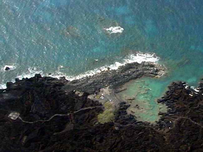
| On the road past Makena beach and halfway through the 1790 lava flow (last
lava flow on Maui), is a walking trail through the the Ahihi-Kinau Natural
Area Preserve. A half hour walk across the lava brings you to the snorkle
pool in this photo. The pool has a narrow inlet to the sea and the rocks
on the bottom are encrusted with coral. Twenty or thirty different species
of fish are easily seen.
|
|
|
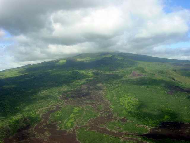
| On the southwest crest of Haleakala is replete with cinder cones and their
associated lava flows. This photo was taken between waypoints (17)
and (18) looking upcountry.
|
|
|
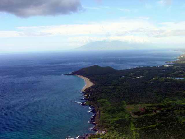
| Last is one of the best beaches on Maui, the strip of sand in the center,
Makena's Big Beach. On the other side of the hill, called Pu'u Ola'i 360
feet tall, is Maui's unofficial nude beach, Little Beach.
|